Three Lakes
The interactive map of Three Lakes can be found on the map page (opens in a new tab).
Click here to go to the Palaeoecology Data for Three Lakes
Topography
The three lakes at Three Lakes, with their surrounding wetland, lie along the south side of the road halfway between Dunmanway and Drimoleague at Long 09 10 35 W Lat 51 40 20 N. They occupy about 60 hectares along the valley bottom just to the east of the watershed in the east-west valley. The total bog/lake area is approximately 2,250 m long and 500 m wide.
At the western end of the wetland area the watershed lies just 250 to 300 metres distant, and no more than 10 metres higher than lake level, beyond which drainage is to the west and to the Ilen river. At the eastern end of the basin the valley narrows to the Clashnacrona gorge, and the floor of the basin rises up to form a lip of bedrock that holds back the drainage.
The valley and gorge are followed by the river draining the lakes (the Brewery River), the road, and the railway, this last dismantled in the 1960s.
To the south lies the hill of Killaveenogue, rising steeply to 278m, and Maulanamirish further east to 298m. To the north side of the valley the hillside is less abruptly steep but reaches a greater height of 355 m at Milane hill. At Clashnacrona the valley bottom narrows to about 250 to 300 m.
Geology and Geomorphology
The valley follows the line of the Dunmanus-Drimoleague fault, formed during the late Carboniferous Variscan orogeny. The underlying and surrounding rock is Late Devonian (the Old Head Formation) to Early Carboniferous mud- and siltstones (Narrow Cove and Pigs Cove members of the Kinsale Formation) giving a slightly acidic soil rich in quartz and poor in calcium. Iron in the sediments and rocks give the characteristic red to purple colours.
The basin was probably glacially formed, as appears to be not uncommon in this area. Clashnacrona gorge is identified as a glacial outwash channe by the Geological Survey of Ireland (GSI), meaning it formed as the result of large volumes of meltwater discharging from the ice sheet and from snow melt at the close of the glaciation. It can be inferred from this that the lakes - or possibly originally one larger lake - formed as the water was held back in the depression by the rock lip in the gorge. As the climate warmed after the glaciation more and more life forms moved into the lake waters and onto the surrounding landscape.
Sediment Cores
The first sediment core (TL1) taken at Three Lakes, to the north of the middle lake, revealed 5.9 metres of peat, the upper layers containing many pieces of wood. The peat is underlain by blue grey silt which appears to be unoxidised and fairly free of organic matter.
(It is important to be careful in distinguishing clay from silt - this sediment has the appearance of clay, but is clearly not. It feels gritty in the mouth - clay would feel smoothe - and if rolled into a ball and thrown at a wall it breaks apart - clay would stick. Silt has a larger grain size (0.05 mm to 0.002 mm) than clay (less than 0.002 mm), and has quite different mineral properties, being comprised principally of small quartz grains, with some metal oxides. The grains will be of various shapes and sizes. Clay minerals have a definite composition, though very varied, principally aluminium and silica, with other metal ions, and are generally of a plate like shape, lying flat, crystals sticking to each other with electrostatic forces - which is what makes clay sticky.)
Radiocarbon dating of three whole peat samples from this core at 1.0 m, 2.9m and 5.8 m depths, gave dates as follows:
- Sample no. Depth Age Date of Deposition
- (radiocarbon years) (calibrated)
- UBA-39773 1.0 m 1417 +/- 25 AD 597- 659
- UBA-39775 2.9 m 8868 +/- 43 BC 8223- 7830
- UBA-39774 5.8 m 10026 +/- 49 BC 9808- 9359
Radiocarbon dating was paid for by a generous grant from IQUA, for which I am most grateful.
It can be seen that, based on the currently derived dates, sedimentation rate has not been constant. Further radiocarbon dates would be required to clarify this and to affirm the ages given.
For a more detailed analysis of the core data refer to the Palaeoecology Data page for Three Lakes. Assuming that the current surface is dated to the present, and taking averages for the various date ranges, the top 1 metre was deposited over about the last 1,400 years. The next 1.9 metres down represents about 8400 years, and the bottom 2.9 metres about 1,500 years.
Thus the average rates of deposition were approximately:
- 1 cm every 5 years for the first 1,500 years
- 1 cm every 44 years for the next 8,400 years
- 1 cm in every 14 years for the last (most recent) 1,400 years
This can be illustrated by a simple graph, using a spreadsheet, as follows -
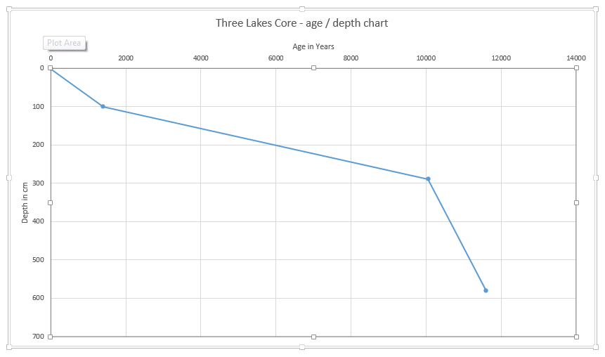
That the rate of deposition changed is clear, but we need more radiocarbon dates to find out exactly where these changes happened. These calculated rates are largely determined by the dates given for the depths chosen, and the initial selection of depths to be dated was arbitrary. It is likely that the rates of deposition varied far more than we can determine from these three dates, and there may even have been hiatuses in the deposition cycle, for whatever reason.
It would appear that the deposition was more rapid in the early days of the mire formation, and this possibly is something to do with the presence of many diatoms in the samples from lower depths, suggesting the sediment was deposited on a lake bottom, before the lake had filled and the mire had started forming.
Early analysis of certain levels in the peat core support this in that lower levels are very high in diatoms, the upper levels have none, suggesting the lakes had a wider expanse reaching at least as far as the coring site, but terrestrialisation has since reduced the lake area.
Within historic times the OS maps 1st edition (c 1840) and 25 inch edition (c. 1880) support this in showing greater areas of open water on the earlier surveys. The dimensions, with obvious reservations regarding the mapping and method of measurement (defining the edge of lakes in a wetland environment is not always simple), are given below.
- Date.......Area.........Dimensions
- ...........of Lake.......(approx.)
- ...........(ha)............(m)
- Eastern Lake
- c.1840......3.4.........380 x 128
- c.1880......3.6.........350 x 125
- Present.....2.6.........330 x 100
- Middle Lake
- c.1840......2.3.........118 x 229 ....1 island
- c.1880......2.5.........125 x 240....2 islands
- Present.....1.0.........100 x 100....2 promontories
- Western Lake
- c.1840......9.2.........753 x 157....1 island
- c.1880......9.3.........758 x 140....1 promontory
- Present.....7.0.........700 x 100....1 promontory
The middle lake is shown as having two islands on the early surveys, but today these are connected, in a lake of reduced area, to the shore as promontories. Further investigation suggests that these are not bedrock based - the valley has several examples of such hillocks in the valley bottom, both in the Three Lakes area and further east, in and beyond the Clashacrona gorge. Water depth in the middle lake is a fairly consistent 2.5 to 3 m.
Hydrology
There are some inflowing streams to the lakes; two from the southern slopes into the largest western lake; two, one from the northern slopes and one from the southern, into the middle lake; and one from the northern slopes into the eastern lake. The three lakes drain, through a channel, from one to the other, from west to east, and thence through the gorge, over the rock lip and on to Dunmanway as the Brewery River. In Dunmanway another river from the north, the Dirty River, joins the Brewery River and this river eventually joins the river Bandon. The channel between the middle lake and the eastern lake is kept clear and appears to be man made, at least in the first few hundred metres from the middle lake eastward, and is possibly a canalisation of an existing drainage channel.
Ecology
The three lakes being surrounded by wetland are what is known as a hydrosere. This ecological term can be loosely defined as the succession of habitats that occur as a lake gradually infills with vegetation as the vegetation dies and collapses into the water at the edge of the lake.
The wetland here is defined as mire, following the guidance in Fossitt's Guide to Habitats of Ireland, being a wetland fed by both ground water and by precipitation. The habitat type Poor Fen and Flush (PF2) can be assigned to these mires on the basis of surrounding geology being acidic and calcium poor. However, pH measurements of the water show the environment to be only slightly acidic. At the coring site pH is 6.35; the water of the middle lake in the floating mat 6.83 ; and in the drain leaving the lake 6.9. Local dryland soils in the immediate area give pH levels of 5.5 to 6.5. As stated above, the largest part of West Cork has an acidic geology comprised of Late Devonian - Early Carboniferous sand-, mud- and siltstone, a siliceous lithology with minimal lime.
Poor Fen and Flush (PF2) is a habitat type that does not occur widely in Ireland and is suggested to therefore be deserving of special conservation status.
A brief survey of plant communities currently existing in the Three Lakes area shows quite a diversity of wetland habitats in close proximity which is suggestive of terrestrialisation, at least in the areas closer to the lake shores. Most of the lake shores are surrounded by floating mat communities of Phragmites reeds, inside which are floating communities of yellow and white water lilies. The Phragmites mats largely conform to the designation of transition mire and quaking bog (PF3) in the habitat listing, and transitions in a short distance from the open water to Poor fen and flush (PF2). As is to be expected with a natural environment that is subject to many variable parameters, the vegetation observed in these areas does not match the descriptions exactly but overall the habitats relate quite closely.
Further out on the mire, on the northern side between the middle lake and the road, rectangular depressions in the mire surface indicate old peat workings, with a habitat designation of Cutover Bog (PB4). The vegetation in these areas has yet to be surveyed closely.
At the eastern end of the middle lake is an area of Wet Willow-Alder-Ash Woodland (WN6), comprised principally of willow with numerous clumps of Royal Fern, and a ground cover of grass, rushes, and sedges and clumps of Kingcup. Ash becomes more frequent in by the drainage channels; alder is present to a lesser degree.
Deer are abundant in this area leaving slots and droppings cleafly visible in the wet ground. Tracks through the wet undergrowth are clearly utilised by deer, and probably foxes, of which droppings have been found. No sign of badgers or otters have yet been found.
References
- Fossitt, J. 2007. Guide to Habitats in Ireland. The Heritage Council.
- JNCC. 2010. Handbook for Phase 1 habitat survey - a technique for environmental audit.
- Website http://webgis.archaeology.ie/historicenvironment/